[ Accessibility | Jump to content]
Bekijk kaart
X

Offshore-constructies

Er bestaan allerlei verschillende typen constructies die verband houden met de offshore olie- en gasindustrie op het Britse Continentaal Plat. Olieplatforms en booreilanden zijn gemakkelijk zichtbaar maar onder het zeeoppervlak bevinden zich nog veel meer constructies die als ze niet vermeden worden voor visserijactiviteiten een ernstig gevaar vormen.

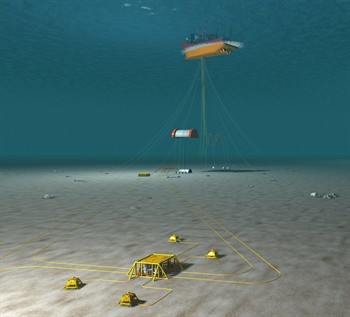
TOp de afbeelding rechts is te zien dat hoewel er slechts één constructie aan het zeeoppervlak zichtbaar is (een FPSO), er verscheidene subsea-constructies aanwezig zijn.

Klik voor meer informatie over specifieke constructies op de onderstaande links.

Surface-constructies

Subsea-constructies

Pijpleidingen

Banff subsea
Afbeelding van FPSO en daarbij betrokken subsurface-installaties
To download the latest oil & gas fishing plotter files, please visit the Download page and view the data on the offshore map by clicking here.

Disclaimer

TO DOWNLOAD THIS FILE, YOU MUST AGREE TO THE TERMS AND CONDITIONS "TERMS" NOTED AT THE FOOT OF THIS WEBSITE WHICH APPLY TO YOUR USE OF THIS WEBSITE AND TO USE OF THE FILE YOU HAVE CLICKED TO DOWNLOAD. IF YOU DO NOT AGREE TO THE TERMS, YOU WILL NOT BE ABLE TO DOWNLOAD THE FILE AND YOU SHOULD NOT USE THIS WEBSITE. TO CONFIRM YOUR ACCEPTANCE OF THE TERMS AND TO COMMENCE THE DOWNLOAD OF THE FILE, PLEASE CLICK THE "DOWNLOAD" BUTTON. IF YOU DO NOT AGREE TO THE TERMS, PLEASE CLICK THE "CANCEL" BUTTON. YOUR ATTENTION IS DRAWN TO CONDITION 3 NOTED BELOW WHICH FORMS PART OF THE TERMS IN RELATION TO OUR LIABILITY TO YOU.

Akkoord en downloaden annuleren
The website stores some data in your browser. We do not store any personal information. By clicking 'OK', you accept this. See our terms and conditions. OK