[ Accessibility | Jump to content]
View Map
X

Offshore Structures

There are many different types of structures associated with the offshore oil and gas industry on the UK Continental Shelf. Oil platforms and drilling rigs are easily visible but below the surface there are many more structures which if not avoided may become serious hazards to fishing operations.

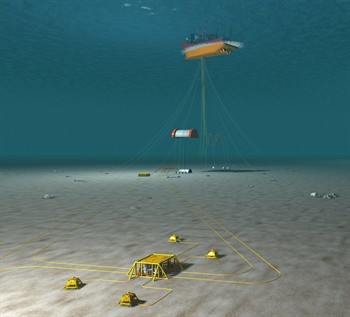
The image displayed to the right shows that although there is only one structure visible from the surface (an FPSO), there are several subsea structures present.

Please follow the links below for more information relating to specific structures:

Surface Structures

Subsea Structures

Pipelines

Banff subsea
View of FPSO and associated subsurface installations

To download the latest oil & gas fishing plotter files, please visit the Download page and view the data on the offshore map by clicking here.

Disclaimer

TO DOWNLOAD THIS FILE, YOU MUST AGREE TO THE TERMS AND CONDITIONS "TERMS" NOTED AT THE FOOT OF THIS WEBSITE WHICH APPLY TO YOUR USE OF THIS WEBSITE AND TO USE OF THE FILE YOU HAVE CLICKED TO DOWNLOAD. IF YOU DO NOT AGREE TO THE TERMS, YOU WILL NOT BE ABLE TO DOWNLOAD THE FILE AND YOU SHOULD NOT USE THIS WEBSITE. TO CONFIRM YOUR ACCEPTANCE OF THE TERMS AND TO COMMENCE THE DOWNLOAD OF THE FILE, PLEASE CLICK THE "DOWNLOAD" BUTTON. IF YOU DO NOT AGREE TO THE TERMS, PLEASE CLICK THE "CANCEL" BUTTON. YOUR ATTENTION IS DRAWN TO CONDITION 3 NOTED BELOW WHICH FORMS PART OF THE TERMS IN RELATION TO OUR LIABILITY TO YOU.

Agree and download Cancel
The website stores some data in your browser. We do not store any personal information. By clicking 'OK', you accept this. See our terms and conditions. OK