


Seismic surveys are carried out extensively in the North Sea to search for potential reserves of oil and gas in the subsea rock formations. Large seismic survey vessels are used to tow steamers suspended below the surface which carry hydrophones. Sound waves are transmitted from the vessel using compressed air guns which travel down through the seabed and reflect back from the different layers of rock. These relfected sound waves are received by the hydrophones located along the seismic streamers which when processed gives a three dimensional picture of the substrata.
 |
| Demonstration of seismic survey activities |
Seismic survey vessels usually tow several streamers behind them (from 1 to 12) and of varying lengths up to 5000 metres. They show shapes and lights for a vessel restricted in its ability to manouevre. The streamers (cables) are spread by diverters, similar to a type of mid-water trawl door, and can extend to over 500 metres in width. The end of each streamer is marked by a tailbuoy carrying radar reflector and flashing lights.
Seismic survey vessels tow at a speed of 4 – 5 knots and need to be on a straight line whilst surveying and are usually accompanied by a “Chase Boat” who will assist in notifying other vessels of the seimic operation. Survey areas vary greatly in size and may cover extensive areas of the sea surface. Please co-operate with seismic survey vessels during your own operations.
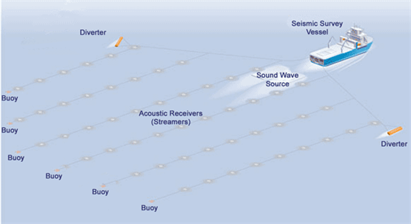 |
| Seismic survey vessel and associated equipment |
| To download the latest oil & gas fishing plotter files, please visit the Download page and view the data on the offshore map by clicking here. |