


Not all structures associated with the offshore oil and gas industry indicate their presence at the surface. For those subsea structures requiring a safety zone, a Statutory Instrument (S.I.) will be created to offer protection to / from other users of the sea.
| Subsea structures form a major part of the offshore oil and gas infrastructure on the UK Continental Shelf. These structures come in a variety of shapes and sizes which include valves on pipelines, tee pieces, production manifolds, templates, active and suspended wells, etc.
In order to offer protection to / from fishing activities, most subsea structures have a 500m safety zone, which is measured from the center of it’s location. |
 |
|
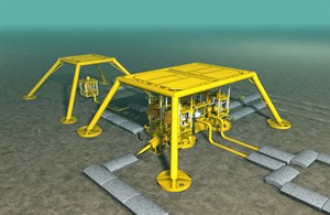
| Subsea structure: Manifold with protection structure |
A subsea structure will only be granted a safety zone following consultation, which includes the respective fishermen’s organisations. Fishing vessels are not permitted to enter safety zones except in connection with the saving or attempted saving of life or property; stress of weather; when in distress or if there is consent from the installation operator.
Vessels should not transit through safety zones even when they are not fishing. According to HSE guidance, a vessel may only enter a safety zone in the following circumstances: to save life or property, owing to bad weather or when in distress.
 |
This how a subsea template is shown on an admiralty chart.
Figures (78) indicate charted depth above the obstuction. |
The schematic drawing below is of an existing installation. A subsea safety zone is active to cover all the pieces of equipment seen in the drawing. There are many vulnerable subsea structures which if not avoided could become serious hazards to fishing operations.
 |
| Schematic drawing indicating the extent of subsea installations |
All subsea safety zones have a 500 metre radius from a central point. This can mark a single object but quite often there may be several pieces of equipment within the safety zone and therefore it is important not to enter these zones whilst carrying out fishing operations.
The image below shows a 500 metre safety zone as the outer circle. The subsea equipment within this zone extends to almost 200 metres from the centre of the zone.
 |
| Typical example of structures within a subsea safety zone |
| To download the latest oil & gas fishing plotter files, please visit the Download page and view the data on the offshore map by clicking here. |