


Production Wells
| When a well is drilled the structure placed on the seabed is called a wellhead. There may be a single wellhead, though often there may be several units grouped together to form a block. Attached to the top of the wellhead are the control units called subsea trees.
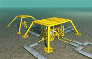
The wellhead assembly is usually contained within a supporting structure called a template, with many also having a protection structure covering all the subsea equipment, as shown in the image to the right. |
 |
|
| Subsea wellheads within a protection structure |
A single wellhead can be 3-4 metres square and up to 5 metres high. When several are grouped together within a template they become very large structures on the seabed.
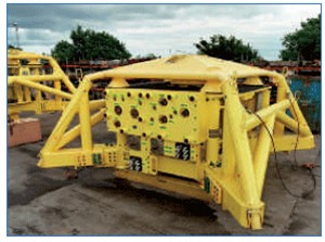 |
| Wellhead and protection structure |
The protection structures covering wellheads and their associated equipment are extremely large structures, which although offering some protection to / from fishing activities, they should still be treated with extreme caution. Below you can see a protection frame seen on the back deck of a support vessel prior to being installed on the seabed. From this picture you can see the scale of these structures by the size of the crewman in the foreground.
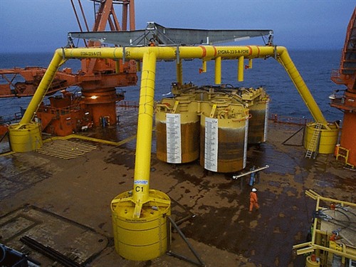 |
| Protection structures on the deck of a support vessel |
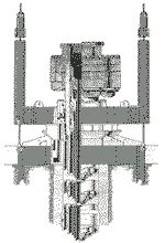
Suspended WellsAfter initial drilling, a well may be temporarily suspended if an operator intends to carry out further operations at a later date. In this event a guide base is left on the seabed to facilitate re-entry if required (as seen in the image on the right). The structure left in place resembles an inverted table with legs approximately 4 metres high. A central pipe about 20 inches in diameter normally projects about 4 – 5 metres from the seabed. Suspended wellheads do not have any safety zones attached to their location and are not usually marked however some may have buoys attached. These structures are therfore extremely vulnerable to fishing operations and should be avoided at all times. The positions of new suspended wells are published in the Offshore News section of this website and the Kingfisher Fortnightly Bulletin. A complete list is available through Kingfisher Information’s Yellow Card listing and as fishing plotter files. |
 |
|
| Suspended wellhead |
| To download the latest oil & gas fishing plotter files, please visit the Download page and view the data on the offshore map by clicking here. |